Automatic and Efficient Data Logging of Weed Management Activities
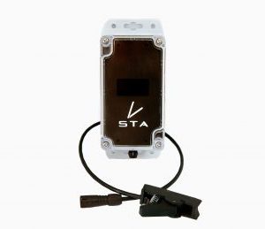
The STA logger is an automated GPS and data logging attachment designed to integrate with your existing weed control tools.
View Pricing CLICK TO WATCH VIDEO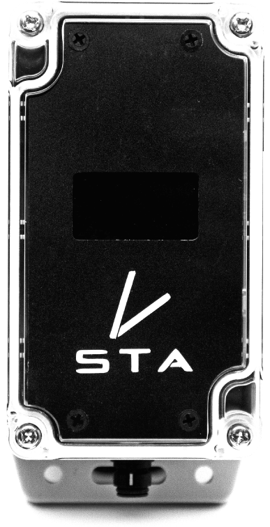
We Help Simplify Weed Mapping, Management and Reporting.
Does your team struggle with the complexities of location devices like handheld GPS? Or do you feel like you require more time and experience to be able to quickly collate, process and analyse weed mapping data? Enter STA Logger. A weed control solution designed for recording the metrics that are important to the forestry, land management and conservation industries.
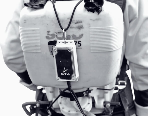
You’ll see where your weed control team has been, where they sprayed and can quickly analyse the patterns with a simple and easy to use reporting system. It’s so easy, field operators simply clip it on and forget it’s there.
We put the control back into your hands with an efficient way of collating your data which will reduce operators’ inefficiencies and improve your reporting to clients, funding bodies and managers.
View Pricing
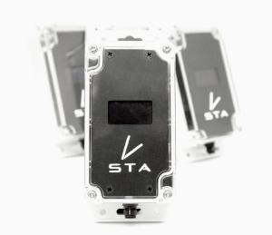
Introducing the STA Logger
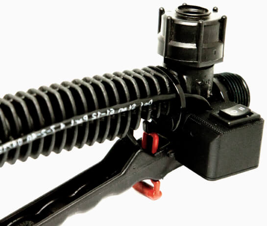
Connect Easily to Spray Equipment
A STA logger device is equipped to your weed control equipment with an integrated switch system fixed to the trigger. We support popular brands of spray equipment and customise setups for less common brands (for an additional cost).
Automatic Location & Weed Spraying Tracking
Once awakened, the STA logger automatically begins tracking your location. The location of trigger presses (i.e. weeds that have been sprayed) are mapped as you work (no additional input required). Optionally, a 3-way toggle switch is present which you can use to group and categorise different weed species if you are spraying more than one type.
Hands Free Data Uploading
Once back in the office, the STA logger is plugged in to charge the battery where it will automatically search for its home Wi-Fi network and begin uploading the data to the cloud. The data is processed and delivered straight back to your reporting portal. It’s so simple, anyone can do it.
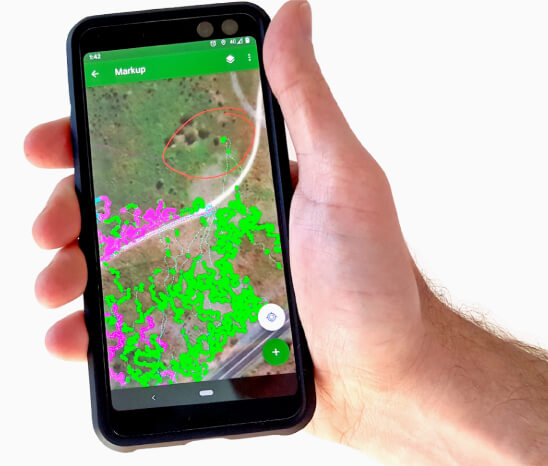
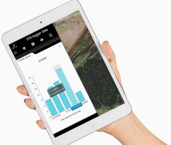
Visualise The Data
Once your data is uploaded, simply log in via a browser to view the tracklogs and spray areas from all your units. Different weed species appear as different colours. Easily click on spray points to view weed mapping details, turn layers on and off, as well as export weed maps too.
The mobile app is GPS enabled meaning field workers can also use this data to continue on from previous day’s work, or navigate to historic weed infestations to follow up and ensure there is no regrowth.

Monitor, Manage & Report
Office workers can monitor their weed control crews progress and analyse metrics such as the distance traversed or area sprayed per day, per unit. Anyone can quickly and easily publish maps of their teams work into a variety of formats (e.g. jpg, pdf, tif & more) for inclusion in reports or updating clients. Mapping weeds has never been simpler.
Why The STA Logger Matters
Simplicity of use
Field operators don’t need to do anything. Once fitted, it is entirely automatic in its data collection and processing. Let your field operators do what they are best at and let the STA logger get you the data you need.
Ease of reporting
Your reports have never been easier with analytics and map production available through browser interface with no technical ability required.
Efficiency
There’s no handling or processing of GPS files and it requires no manual intervention of any kind (other than charging a unit’s battery) making all your weed management operations highly efficient.
Field viewing of data
Allow your operators to use Esri supported mobile apps in the field to navigate to infestations and locate weeds. iOS, Android and Windows are all supported.
Designed for the land management industry
Unlike other devices that are designed for general purpose or agricultural use, the STA logger is designed for recording and reporting the weed control metrics that are important to forestry, land management and conservation industries.
Integrate into your GIS
If your organisation or client uses GIS, they can add the data as a layer (without download) for advanced analysis or map production.
Pricing & Costs
STA logger pricing includes the purchase price of the hardware and subscription in the first year, with ongoing annual subscriptions in subsequent years. Bulk pricing available.
High-volume
For integration with high-volume vehicle and ATV mounted spray units.
YEAR 1
$1150 PER UNIT
YEAR 2 AND ONWARD
$365 PER UNIT
All prices are in AUD and are GST exclusive. Minimum purchase quantity of 2.
Backpack
For equipping to low-flow backpack sprayers.
YEAR 1
$890 PER UNIT
YEAR 2 AND ONWARD
$365 PER UNIT
All prices are in AUD and are GST exclusive. Minimum purchase quantity of 4.
TREE PLANTER
For equipping to tree planting tools.

MOUNT AND SWITCH
$350 PER UNIT
DOES NOT COME WITH A STA LOGGER
OR SUBSCRIPTION
All prices are in AUD and are GST exclusive.
Rental
For short term projects
Australia only.
Minimum rental of 2 units for 1 month.
Enterprise and bulk
CUSTOMISE YOUR SETUP TO SUIT YOUR ORGANISATION'S NEEDS INCLUDING GIS INTEGRATIONS.
Who Needs Our STA Logger?
Private Contractors
Contractors that offer weed management, land management, site rehabilitation/restoration services.
Government and Industry
Organisations who have weed management teams or engage private contractors. Industry (like forestry, mining, oil and gas, water, planning, etc.) who have legal environmental obligations and are required to report to
STA Logger Has Been Used on Projects For...


Frequently Asked Questions
-
CAN I DOWNLOAD THE DATA?
You can export the raw GPS data to .csv and is similar to conventional weed mapping data. Processed data download (track lines and spray areas) can be enabled if you contact support and have the required software and expertise. Though, for most visualisation and map production purposes, this isn’t required.
-
CAN I MOVE IT TO OTHER LOCATIONS AND UPLOAD VIA OTHER WI-FI ACCESS POINTS?
The unit needs to be connected to a single Wi-Fi access point. If you need to change the access point, it can be done through the settings but changing frequently is not recommended.
-
CAN I RENT A LOGGER?
As of September 2022, we offer rentals to Australia only. Contact us for details.
-
WHY IS THE HIGH-VOLUME VERSION MORE EXPENSIVE?
The high-volume version has additional parts and a lower minimum purchase quantity (2) than the backpack version.
-
CAN I USE THE LOGGER WITHOUT A SUBSCRIPTION?
No. The subscription enables the upload, processing, data storage and availability of maps. Without it, none of these processes will work. It is against the terms of use to use the device without a subscription. Read our blog for more info on what value you get from the subscription.
-
CAN IT BE USED ON BOOM SPRAYERS?
While it wasn’t designed for boom spraying applications, some users have adapted it for this purpose. This usually requires some degree of customisation on the part of the trigger mechanism. Contact us to discuss your options.
-
DO YOU HAVE SPARE PARTS?
Yes, we have spare parts on hand. View them at stalogger.com/blog/spare-parts/ or contact support@terralabgis.com to inquire.
-
DO YOU OFFER SUPPORT?
Yes. A subscription includes support. Contact support@terralabgis.com for assistance.
-
HOW DO I VIEW THE DATA?
When you purchase a valid subscription, you will be given access to a web based app that you view through your browser or on your mobile device. With license upgrades, or bring-your-own license options, data can be viewed in the field through ArcGIS native mobile applications giving your weed control team greater ability to locate weeds in the field.
-
WHAT TYPE OF WIFI DOES THE STA LOGGER USE?
The STA loggers use 2.4 GHz WiFi. Your modem will need to be compatible.
-
WILL I KNOW HOW BIG WEED PATCHES ARE?
Yes. The STA logger estimates the weed sprayer footprint (spray zone) when you pull the trigger. This data is represented as a polygon which has an area. This area is an objective and repeatable estimate of the weed cover for that patch of weeds. When analysed at the scale of the site, this is a powerful metric for tracking the change in weed cover and weed density over time.
-
HOW DOES IT UPLOAD TO THE CLOUD?
The unit works offline meaning it does not need cellular coverage. When the unit is connected to a charger, it will search for its home Wi-Fi access point and upload the data. You must have sufficient 2.4 Ghz Wi-Fi signal at your point of charging.
-
HOW LONG WILL IT TAKE TO GET ONE?
It depends on the quantity and complexity of the order. For small, standard orders we will have stock on hand to ship immediately. For larger or custom orders there is some lag time as we will assemble to order.
-
HOW MUCH DOES IT COST?
Refer to the pricing page.
-
IS THERE A MINIMUM PURCHASE QUANTITY?
Yes. For backpack sprayers, the minimum quantity is 4. For high-volume sprayers the minimum quantity is 2.
-
WHAT SPRAYERS CAN IT FIT TO?
It is designed to fit to a range of weed control tools such as backpack sprayers, vehicle mounted (high-volume) sprayers and ATV’s. Though, the fittings are specific to certain spray handles. Currently supported spray handles include the Solo sprayer shut-off valve, the Turbo 400, the Hudson 38505 Ges heavy duty spray gun and the TeeJet AAB30A. The list of supported spray handles is constantly updating so please check your brand with us. If you require STA loggers for unsupported spray handles, we can customise our fittings for your needs.
-
WHERE ARE THEY MADE?
STA loggers are designed and assembled in Australia.
-
WHY IS THE FIRST YEAR PRICE HIGHER?
The first year price includes the cost of the hardware plus the subscription.
-
WHY IS THERE A COST PER YEAR?
The STA logger is not just the hardware, but also the cloud based processing, storage, web and mobile tools and support. The STA logger will not work without the subscription.
-
CAN I USE IT FOR WEED MAPPING?
Yes, the STA logger is designed to map weeds while you spray. Categorise different weed species using the selector switch while conducting weed control. Prepare weed maps or export to different formats. It is a complete weed management solution.
-
CAN I MAP DIFFERENT WEED SPECIES?
Yes. The selector switch allows the user to map up to three different weed species (or categories of weeds). These appear as different colours in the map. You can also designate names for each selector switch option in the device settings. For example, you may designate option 0 as "Blackberry", option 1 as "Thistles" and option 2 as "other". Or you may choose to be more general and designate option 0 as "woody weeds", option 1 as "grass weeds" and option 2 as "other". This makes it easier to interpret and analyse your weed mapping data at a later time.